AUSTIN, Texas — Editor's note: This blog is no longer active. For updates on the storm system expected to move into Central Texas on March 24 and March 25, check out KVUE's weather blog.
LIVE UPDATES:
2:20 a.m. – Severe Thunderstorm Warning issued for parts of Caldwell, Bastrop, Lee and Fayette counties until 3:15 a.m. Ping pong ball-sized hail and gusts of 60 mph are possible.
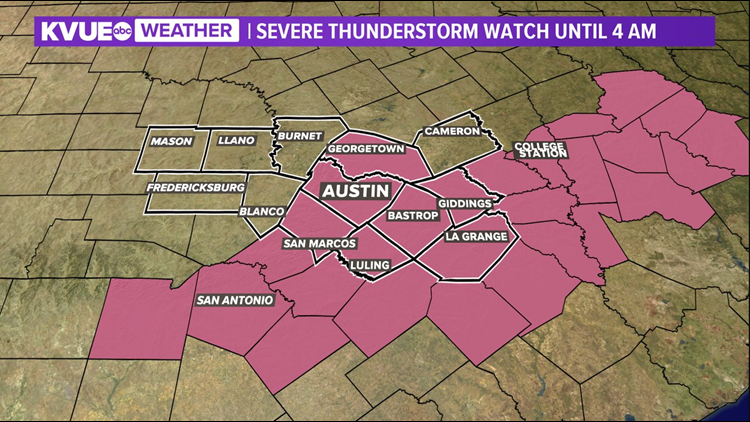
2 a.m. – The Severe Thunderstorm Watch has been dropped in Blanco, Gillespie and Milam counties. Williamson, Travis, Hays, Caldwell, Bastrop, Lee and Fayette counties remain under a Severe Thunderstorm Watch until 4 a.m.
1:50 p.m. – The strong line of storms moving east through Hays and Caldwell counties contains wind gusts up to 60 mph and the potential for golf ball-sized hail. This system is moving east at 40 mph.
1:32 a.m. – The National Weather Service says that the rotation associated with the Tornado Warning in parts of Hays County has weakened and been replaced by a Severe Thunderstorm Warning capable of producing 60 mph winds and quarter-sized hail.
1:30 a.m. – A Severe Thunderstorm Warning is in effect for Hays, Bastrop, Caldwell and Travis counties until 2:30 a.m.
1:10 a.m. – A Tornado Warning has been issued for parts of Hays County until 1:30 a.m.


12:40 a.m. – A Severe Thunderstorm Warning is in effect for parts of Blanco and Hays counties until 1:30 a.m. Sixth mph wind gusts and hail up to a quarter-size is possible.
12:35 a.m. – Several buildings along Highway 29 in Bertram have been severely damaged. There have been unconfirmed reports of a tornado, but there has been no official confirmation. KVUE's Luis de Leon took this footage from the scene:
(NOTE: On Tuesday, the National Weather Service said the damage was caused by straight-line winds, not a tornado.)
12:30 a.m. – A line of storms has strengthened just south of the Hill Country. The Severe Thunderstorm Warning associated with these storms remains south of the KVUE viewing area. A Severe Thunderstorm Warning remains in effect for Milam County and is set to expire at 1 a.m.
11:45 p.m. – A Severe Thunderstorm Warning is in effect for Milam County until midnight. Storms moving through Travis County are currently below severe levels.
A Severe Thunderstorm Warning is also in effect for southern Gillespie County until 4 a.m., as storms develop farther west.
11:20 p.m. – The storms moving into the Austin metro area are below severe limits, but residents should still expect the possibility of heavy rain, lightning, gusty winds and even some small hail.
11:16 p.m. – Severe Thunderstorm Watch extended farther east across the KVUE viewing area. It is set to expire at 4 a.m. as the potential for large hail, gusty winds and tornadoes continues.
10:54 p.m. – Tornado Warning expires for parts of Williamson County. Thunderstorm warning now for Bell and Milam counties until midnight. Storms are moving fast.
10:28 p.m. – A Tornado Warning is in effect for parts of Williamson County until 11:15 p.m.
Pre-10 p.m –
The KVUE Storm Team is currently tracking strong to severe storms pushing through Central Texas.
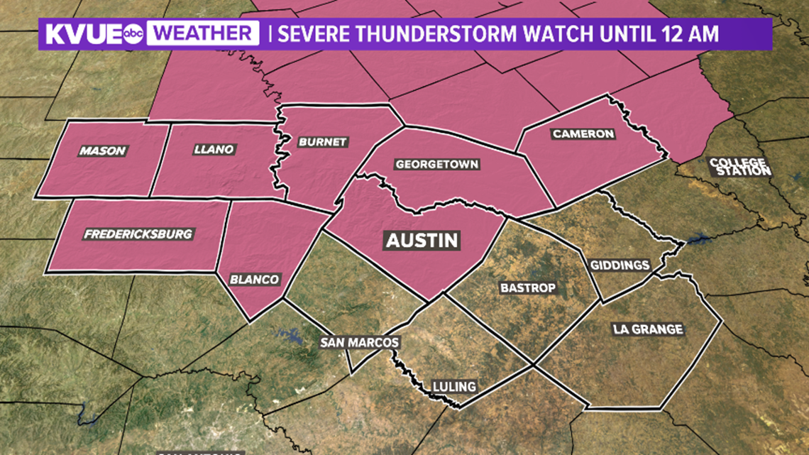
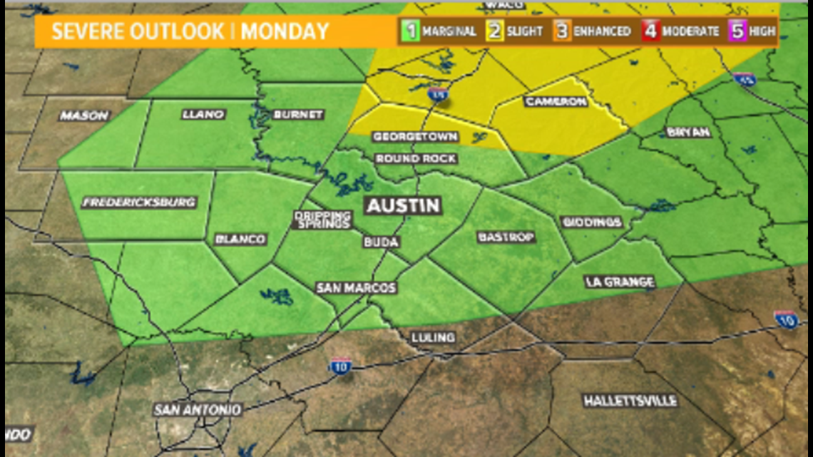
A Severe Thunderstorm Watch is currently in effect for Mason, Llano, Gillespie, Burnet, Blanco, Williamson, Travis and Milam counties until midnight Tuesday.

A cold front is currently moving through Central Texas generating severe storms. The greatest threat is large hail and damaging winds. Strong storms could produce heavy rain and lightning as well.
The Storm Prediction Center has upgraded the severe threat with a "slight risk" for severe storms to now include parts of Williamson and Milam counties.

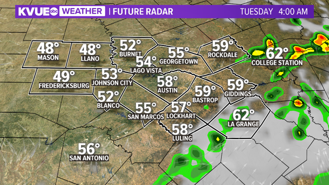
Rain and storms will continue to push eastward through late Monday night, but additional storms could fire up behind the first round into the early overnight hours.

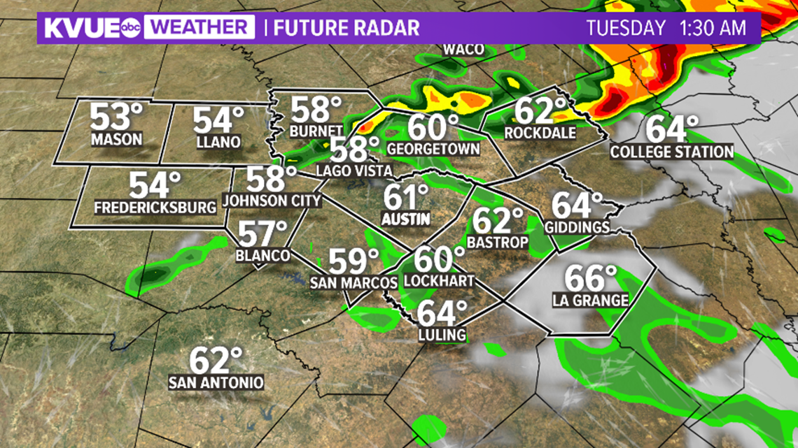
The bulk of the rain and storms should be over by around 3 or 4 a.m. Tuesday.

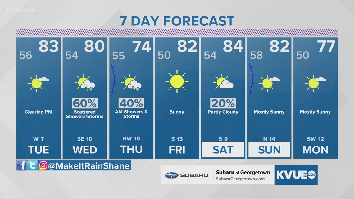
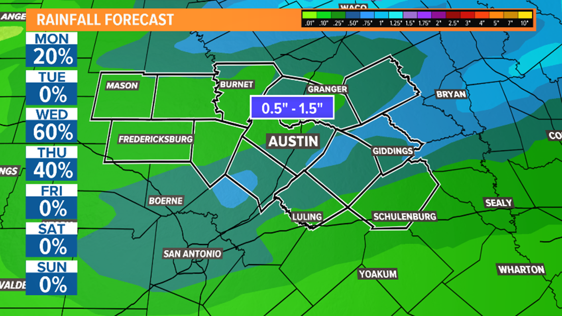
Tuesday will briefly trend drier with a mostly sunny sky for the afternoon and highs in the 80s. The second system arrives mid-week, bringing more showers and storms and another chance that a few storms could be strong to severe.
We'll be tracking that system with further details as it develops, but for now, plan on the possibility of rain and storms Wednesday through Thursday morning.

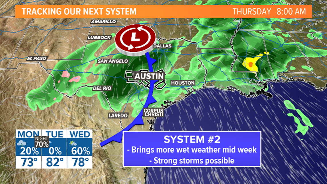
Overall, it looks like rainfall totals next week will be in the half-inch to inch-and-a-half range. This is great news as Central Texas is currently under a moderate drought with a severe drought starting to build in for parts of the KVUE viewing area.

The KVUE Storm Team will continue to update this developing forecast. Be sure to download KVUE's app for updates and to check the radar 24/7: kvue.com/app. Also be sure to follow KVUE on Facebook, Twitter, YouTube and Instagram.
The extended forecast can be found below: