
AUSTIN, Texas — LIVE BLOG:
- Severe thunderstorm warning for southern portions of Caldwell County until 2:15 a.m. for the threat of 60 mph wind and nickel sized hail.
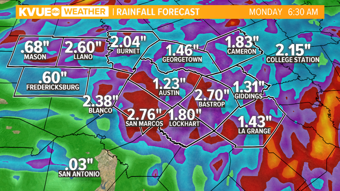
- Flash flood warning issued for parts of Bastrop, Caldwell, Hays and Travis counties until 4:15 a.m. due to heavy rain from storms moving through the area. Up to three inches of rain have reportedly fallen in some spots.
- The severe thunderstorm warning for Travis and Williamson County was canceled by the National Weather Service at 12:43 a.m.
- A severe thunderstorm warning has been issued for parts of Williamson and Travis County until 1 a.m. for a storm moving southeast at 15 mph. The main threats with the storm are 60 mph winds and quarter-sized hail.
- A flash flood warning has been issued for Lee County until 2:00 a.m. Heavy rain across an area of northern and northeastern Lee County has left the area with up to three inches of rain. Areas impacted include Lexington, Dime Box, Tanglewood, Fedor, Lake Somerville State Park & Trailway, Leo and Old Dime Box.
- The National Weather Service has canceled the flash flood warning for Mason County.
- A flash flood advisory has been issued for eastern parts of Williamson County after heavy rainfall moved through from thunderstorms. Up to two inches of rain have already fallen with more rain possible later tonight, which could bring a threat of flash flooding.
-Tornado warning issued for Gillespie County until 10:45 p.m. At 10:05 p.m. a severe storm capable of producing a tornado was located near Mountain Home in Kerr County, moving southeast at 25 mph. This storm is moving into parts of Gillespie County, which is why they are also included in the warning. Those in southwest portions of Gillespie County should take cover immediately in an interior room, away from windows.
- Severe thunderstorm warning in Williamson County expired by the National Weather Service.
- A severe thunderstorm warning has been issued for Gillespie County until 10:45 p.m. on Sunday for a storm capable of producing two-inch sized hail and 60 mph winds. The storm is moving southeast at 25 mph.
- A severe thunderstorm in Williamson County was located over Weir at 9:15 p.m., moving east at 10 mph. The storm may produce 60 mph winds with penny-sized hail. The warning is in place until 10 p.m. on Sunday.
- Quarter-sized hail was reported in Georgetown at 9:00 p.m. as a severe warned storm moved through.
- A severe thunderstorm warning was issued for Williamson County until 10:00 p.m. for a storm moving east at 15 mph, capable of producing 60 mph winds and quarter-sized hail.
- A severe thunderstorm warning was issued for Milam County until 9:15 p.m. for a storm moving east at 35 mph capable of producing 60 mph winds and quarter-sized hail.
- A Severe Thunderstorm Watch is issued for Travis County – and the entire KVUE viewing area – until 3 a.m.
- A Severe Thunderstorm Warning including Georgetown, Taylor and Serenada is in effect until 10 p.m.
- A Severe Thunderstorm Warning is issued for Taylor, Bartlett and Granger until 9:15 p.m.
- A Severe Thunderstorm Warning is issued for Mason County until 7:45 p.m. Large hail and damaging winds are possible.
BACKGROUND:
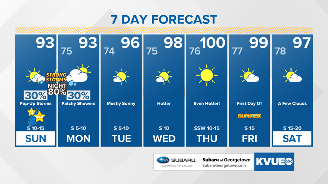
As we wrap up the weekend and embrace the goodness of showering our fathers with our love and thanksgiving, there now exists a risk for strong to severe storms across the area.
Storms will begin surging south into the Central Texas region after dinner Sunday night. As of now, the best time frame for rain and severe weather will be somewhere between 9 p.m. to 12 a.m.

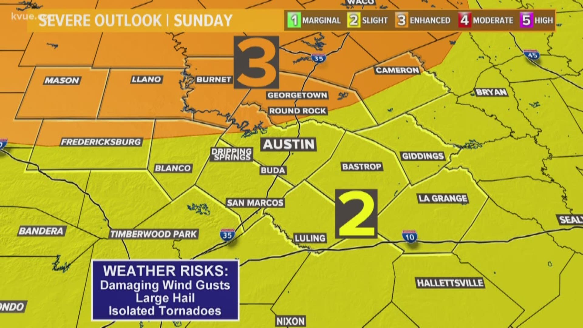
The Storm Prediction Center has upgraded our threat to an "Enhanced Risk," which is a 3 out of 5 on the severe weather threat chart.
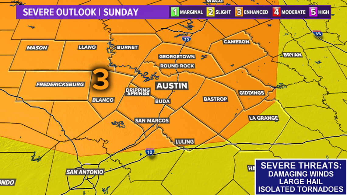
The main threats will be damaging winds and large hail with an isolated tornado possible as well.
Storms could linger into early Monday morning, but should be long gone by sunrise.

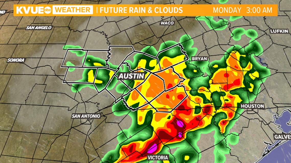
Flash flooding could likely be a threat for low-water crossings, secondary roads and urban areas.
A few residual showers will be possible for Monday, albeit light, before a dry and hot trend takes us into the last remaining days of spring. Our first triple-digit temperature of 2019 could happen on the last day of spring and likely the first day of summer on Friday.
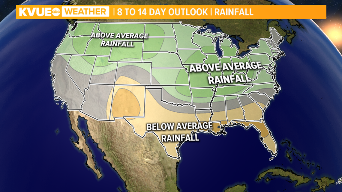
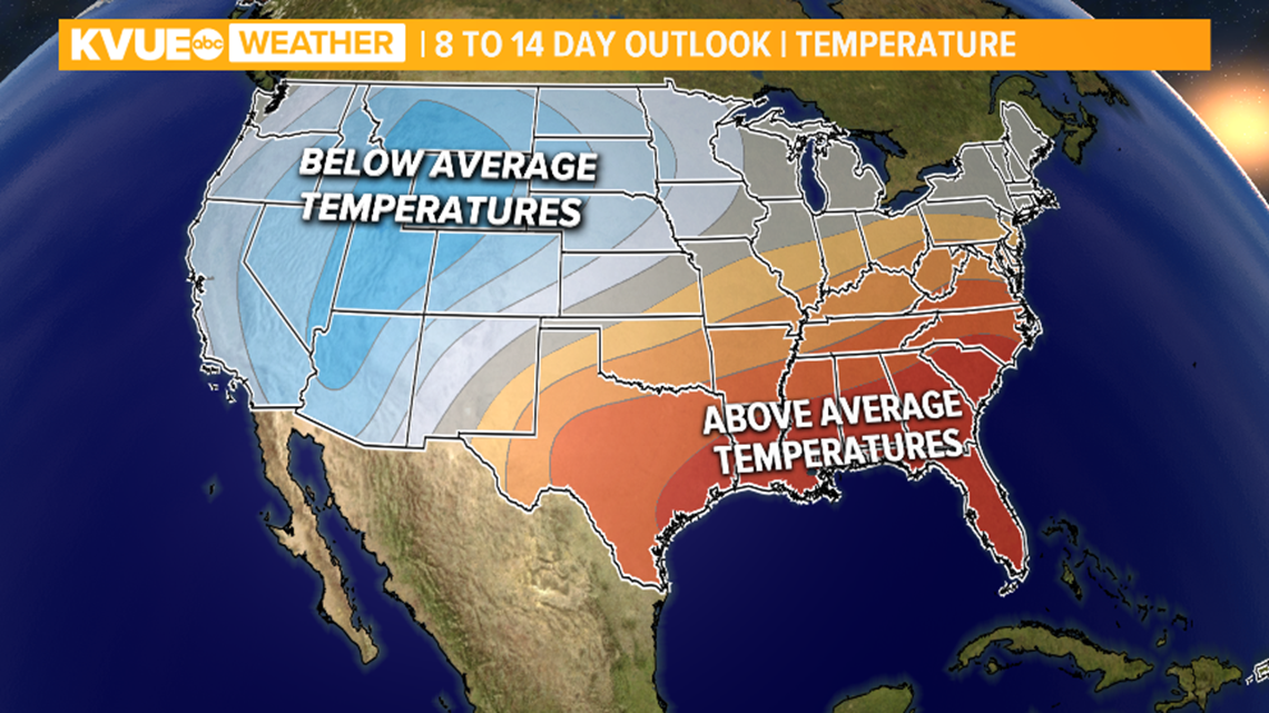
Looking ahead through the end of the month, long-range forecasts are calling for slightly below-average rainfall and temperatures warmer than average for the Gulf, southeastern and mid-Atlantic states.
PEOPLE ARE ALSO READING: