AUSTIN, Texas — Central Texas is no stranger to winter snaps at the beginning of the year, and it looks like our strongest cooldown of the season so far is on the way!
There is still some uncertainty on the exact details, so let's break down what we're confident about at this point.
Timing
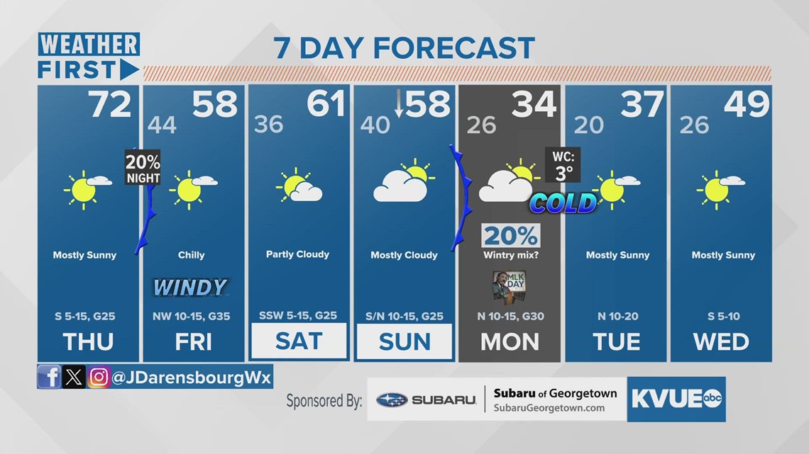
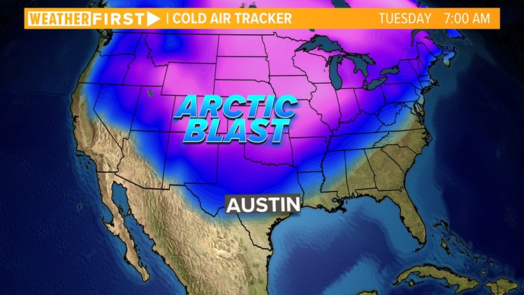
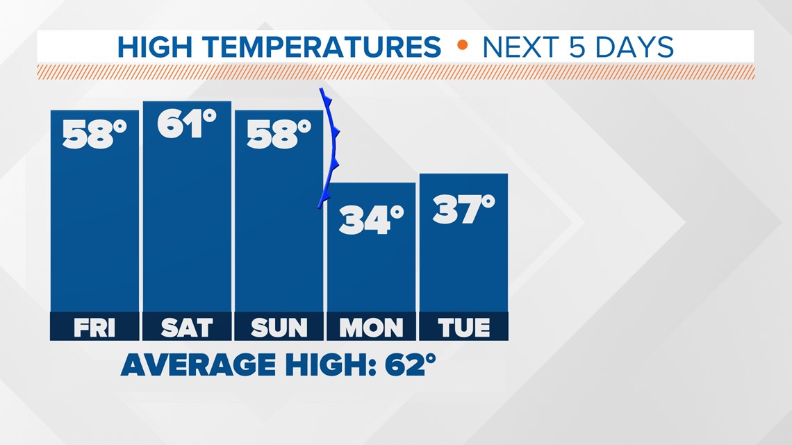
A strong push of cold air will start to move in behind a cold front on Sunday. The most recent forecast models have hinted at an earlier arrival with colder air moving in Sunday afternoon. Temperatures will continue to drop throughout Sunday night and will remain well below average through at least the first half of next week. Ahead of the front, we expect fairly mild conditions for Saturday and Sunday.


Drastic drop in temperatures
Forecast models continue to show agreement temperatures will plummet starting on Sunday afternoon. A widespread freeze is expected for Central Texas Sunday night into Monday morning with dangerously cold temperatures in the teens and 20s. "Feels like" temperatures could be in the single digits due to windy conditions from the north.
The most recent forecast model runs show temperatures struggling to make it above freezing on Monday afternoon. There is a slight possibility our area will remain at or below freezing on Monday, with temperatures not returning above freezing until Tuesday afternoon.

The coldest temperatures during this event will be Monday night. While our forecast calls for Austin to drop into the lower 20s, some locations, especially in the Hill Country, could drop into the single digits, with wind chills possibly below zero! It's extremely important to make sure you have a plan to protect the 4 Ps – people, pets, pipes and plants – as early as Sunday evening.
We expect our forecast numbers to change slightly as we get closer to the arrival of this event, so we'll continue to iron out the details over the next couple of days.
Wintry precipitation?
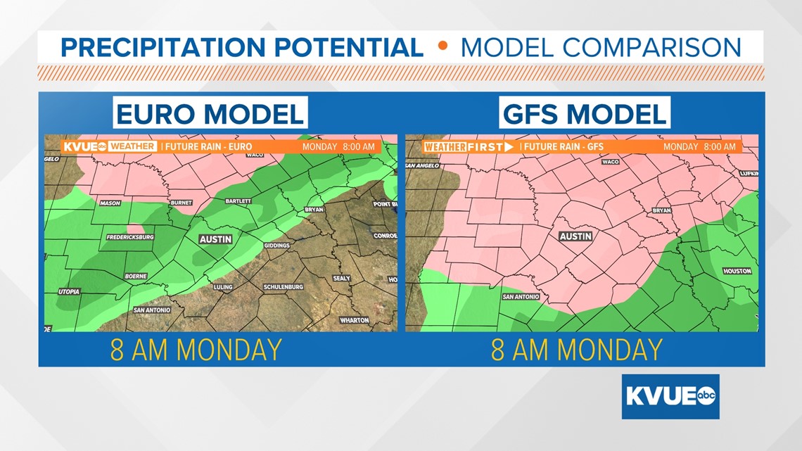
After consecutive years of significant ice or snow events, it's understandable that many Central Texans will be concerned about the potential for wintry precipitation during this event. This is the part of the forecast with the highest uncertainty at this time. The most recent forecast models have now started to show at least some slight wintry precipitation for early Monday. This would most likely arrive in the form of freezing rain, as the American model is more confident in, although the latest European model runs have this only northwest of Austin, with the rest of the KVUE area dealing with regular rain showers.
It is worth noting that some models depict the potential for freezing rain or even a few flurries, although it is likely that this will be light in nature, leading to only road impacts, and not glazing on trees or powerlines, which would cause power outages. It is for this reason our current forecast has a 20-30% chance of precipitation early Monday morning. Since this event is many days out, we will continue to provide updates on these chances daily.

The bottom line
The strongest cooldown of the season so far is expected to begin Sunday and bring dangerously cold temperatures for the first half of next week. While the potential for wintry precipitation can't be ruled out at this time, most forecast models have Central Texas dry for this upcoming event.
The KVUE Weather Team will continue to monitor the forecast closely and provide updates on air and online. In the meantime, here is a look at your extended forecast: