AUSTIN, Texas — Editor's note: This storm has passed through the Austin area, making way for clear skies. This live blog is no longer updating.
All watches and warnings have been cleared after a storm moved through Central Texas March 24 into March 25.
A Tornado Watch had been issued for the Hill Country and Interstate 35 corridor until 4 a.m. Thursday morning, but that watch has since been lifted. A Tornado Watch means conditions are conducive for severe storms capable of hail up to tennis-ball size, damaging wind gusts and a couple of tornadoes.
Much of the Hill Country was under an "enhanced" – level 3 of 5 – risk for severe weather.
Much of the Austin metro was included in the "slight" – level 2 of 5 – risk for severe storms. There was a "marginal" – level 1 of 5 – risk for severe weather through Fayette County. So all of Central Texas had a chance to see severe weather Wednesday into Thursday.
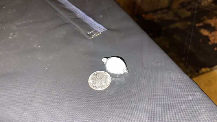
Austin hail storm: Your photos


Be sure to download KVUE's app for updates and to check radar 24/7: kvue.com/app.
Here's a live blog of what we're tracking as the storms move through:
6:11 a.m. - Storms have mostly moved out, and now windy weather moves in.
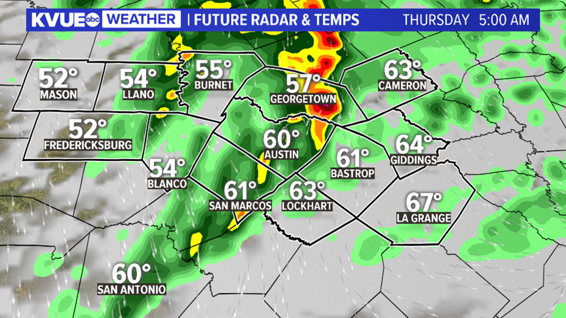
5 a.m. - There are no current warnings or watches in the KVUE viewing area.
4 a.m. - The storm has moved over Dripping Springs and will be heading to the Interstate 35 corridor within 30 to 35 minutes.
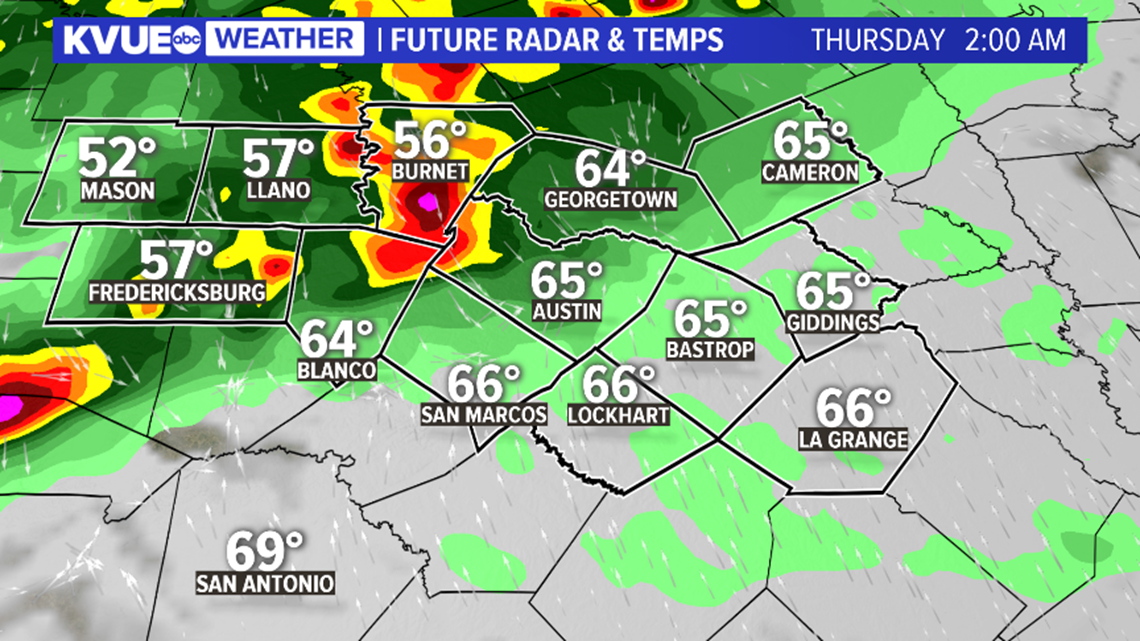
2:41 a.m. - Moderate to heavy rainfall is moving into the I-35 corridor, but non-severe. Rain is moving into a more stable atmosphere. Not ruling out a stray severe storm, but energy is limited.
2 a.m. - Heavy to moderate rain approaches the I-35 corridor.
1:40 a.m. - The storm and hail threats have decreased, but moderate to heavy rain and gusty winds are still expected.
12:45 a.m. - There are currently no active warnings. However, a Tornado Watch is still in effect until 4 a.m.
11:33 p.m. - A Severe Thunderstorm Warning has been issued for Mason County until 12:15 a.m.
11:30 p.m. - A Severe Thunderstorm Warning has been issued for Llano and Gillespie County until 12:30 a.m.
10:41 p.m. - A Tornado Warning for Mason County in effect until 11:15 p.m.
9:54 p.m. - A Severe Thunderstorm Warning is in effect for McCulloch, Kimble, Mason and Menard County until 10:45 p.m.
9:49 p.m. - A Tornado Watch has been issued for many parts of the KVUE viewing area, including Austin and San Marcos until 4 a.m.
9:26 p.m. - Strong storms are approaching the Mason County area.
8:30 p.m. - Storms continue developing west of the KVUE viewing area, traveling northeast.
8:19 p.m. - A Severe Thunderstorm Watch could soon be issued for parts of the Hill Country.
5:50 p.m. - A Tornado Warning is currently in effect outside of the KVUE viewing area in Coryell, Hamilton, Lampasas and Mills counties until 6:30 p.m.
5:31 p.m. - Isolated supercells could develop along a dryline in the Hill Country this evening. Notice showers and storms becoming widespread overnight as a cold front pushes through. Large hail, damaging winds and isolated tornadoes will all be a threat with this storm.
5:12 p.m. - We are currently seeing isolated storms to the northwest in Central Texas. The higher threat for severe storms will begin around midnight for the Hill Country. The Interstate 35 corridor should see activity around 5 a.m. The main threats will be large hail, isolated tornadoes and strong wind.
4:45 p.m. - There is an active Tornado Warning in San Saba County until 5:15 p.m. This is a radar-indicated warning as a severe thunderstorm capable of producing a tornado was detected near Richland Springs moving northeast at 25 mph.
4:38 p.m. - A Tornado Watch is in effect for Mason, Llano and Burnet counties until 10 p.m.
4:09 p.m. - A Severe Thunderstorm Warning is in effect just outside of the KVUE viewing area in McCulloch and San Saba counties. This storm is caused by the dryline moving east. The warning is set to expire at 4:45 p.m.
Here's a timeline that breaks down when we expect to see the next system move through.
Severe weather timeline:
Storm activity will spread eastward across Central Texas through the overnight hours. The highest severe weather risk will be along and west of I-35, but all of Central Texas has the potential for severe weather tonight.

The Tornado Watch is scheduled to expire at 4 a.m. Thursday, but showers and storms could linger for our eastern most areas even through about 8 a.m. Thursday.

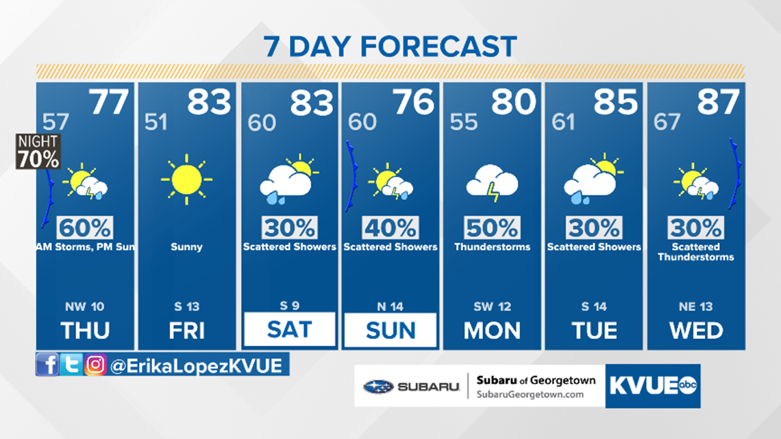
Storms will clear Central Texas by 8 a.m. Thursday morning. Skies will clear with plenty of sunshine in store Thursday afternoon. A breezy northwest wind will be in place with gusts of us to 25 mph possible.
Sunshine hangs around through Friday until clouds and rain chances return for the weekend. Another overnight cold front is expected Saturday and Sunday. At this time, the severe threat is low but a few strong storms will be possible.
Rain chances stick around next week with showers and storms possible Monday and daily rain chances expected for at least the first half of the workweek.