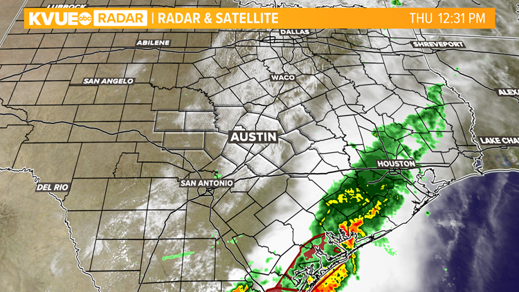
AUSTIN, Texas — As of Thursday afternoon, all Flash Flood Warnings have been allowed to expire for the KVUE area. However, much of Hays and Caldwell Counties picked up over a half foot of rain since last night, so closed low water crossings and river flooding remain a concern.
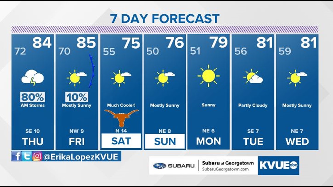
Thankfully, all of the rain has now moved away to the east, and the rest of this afternoon will be dry with gradual clearing and highs reaching the low to mid 80s.
A strong cold front is still set to sweep through Central Texas during the day tomorrow, but this front will struggle to produce much if any rainfall since the atmosphere is already worked over from last nights heavy rain.
Behind the front, we get our first real taste of fall for the weekend as highs drop to the 70s with morning lows in the 40s and 50s. More importantly, the weekend forecast is also completely dry.
Here are the latest updates:
11:29 a.m. – Barton Springs Pool is closed due to flooding. Officials said the pool will reopen when flooding stops and any damage can be repaired. Deep Eddy and Stacy pools are still open.
10:27 a.m. – The Texas Department of Transportation said State Highway 80 at the Blanco River in San Marcos is now open.
10 a.m. – The Highway 80 bridge over the Blanco River in San Marcos is closed while first responders work to evacuate some residents in the water, according to the National Weather Service.
8:15 a.m. – The Flash Flood Warning continues for New Braunfels and San Marcos until 10:45 a.m., according to the National Weather Service.
7:44 a.m. – In San Marcos, the Blanco River has reached 24.6 feet, which means it's in the "moderate flood" stage. The moderate flood stage is 24 feet. KVUE's Mariel Ruiz reports that the last time the Blanco River reached this height in San Marcos was May 9, 2019.
6:47 a.m. – Estimated radar rainfall totals show upwards of 9 inches of rain in Hays and Caldwell counties.
6:30 a.m. – The Blanco River at Wimberley just recorded 10.2 feet. The minor flood stage is 13 feet.
6:26 a.m. – 99 roads are closed due to flooding this morning around the Austin metro and surrounding areas. Remember, water can deteriorate roads. Avoid water-covered roadways. Check ATXfloods.com for updates.
5:42 a.m. – The Blanco River is swollen outside Wimberley Thursday morning after storms brought up to 7 inches of rain to the area.
5:40 a.m. – Flash Flood Warnings include eastern Hays, Caldwell and Fayette Counties. Stay off covered roadways.
5:30 a.m. – Several counties have been taken out of a Flash Flood Watch for the Austin area. Hays, Caldwell, Bastrop, Lee and Fayette counties are now included in the Flash Flood Watch until 7 p.m. Thursday.
5:10 a.m. – A Flash Flood Warning is in effect for Fayette County until 8:15 a.m.
4:45 a.m. – A Severe Thunderstorm Warning has been issued for Fayette, Lavaca and Gonzales counties until 5:30 a.m.
12 a.m. – A Flood Advisory has been issued for Caldwell County until 3 a.m.
11:50 p.m. – A Flash Flood Warning for southern Blanco County has been extended until 2 a.m.
11:45 p.m. – At least 43 low water crossings are closed across the Austin area according to ATXFloods.
11 p.m. – A Flash Flood Warning has been issued for Hays County until 2 a.m. One to 3 inches of rain has fallen, with additional amounts up to 2 inches.
9:35 p.m. – A Flood Advisory has been issued for western Hays County. Minor flooding is ongoing or expected. Up to 2 inches of rain have fallen in some spots.
9 p.m. – A Flash Flood Warning has been issued for southern Blanco County until midnight. Up to 3 inches of rain has fallen with additional totals of up to 2 inches possible.
Timeline:
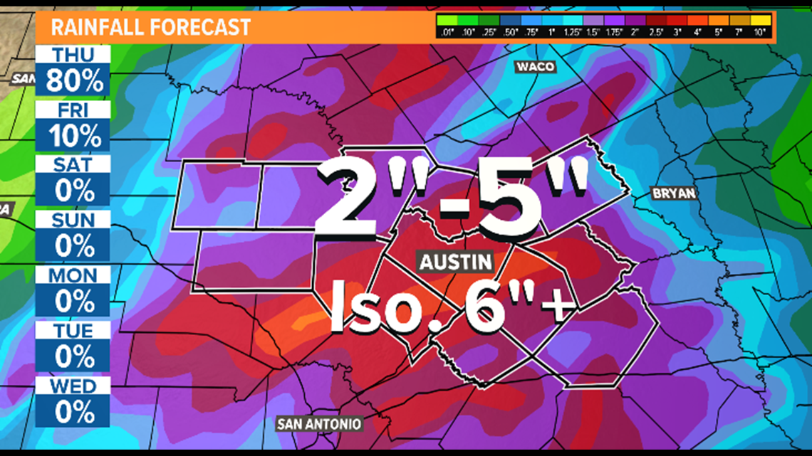
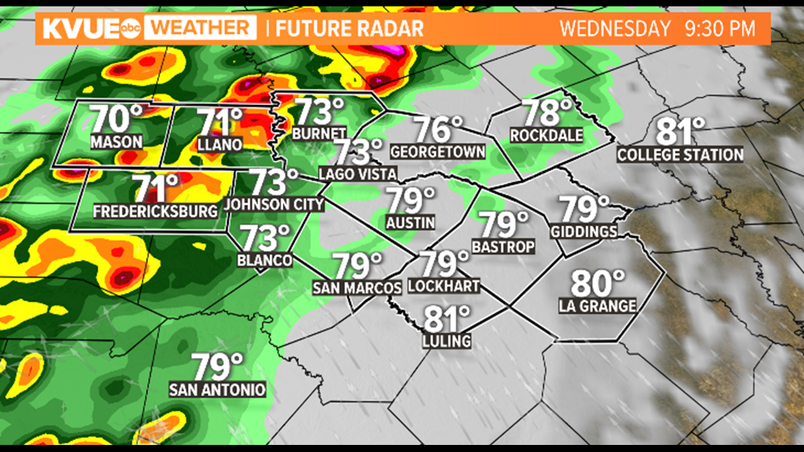
Wednesday and Thursday will be the days we need to stay weather aware as the National Weather Service has issued a Flash Flood Watch ahead of the tropical moisture moving in from Pamela in the Pacific, and a slow-moving cold front that will be pushing through Central Texas. The Flash Flood Watch is in effect from Wednesday morning through Thursday evening for counties along and west of Interstate 35. Due to recent forecast model projections, Bastrop and Caldwell County have also been added to the watch.

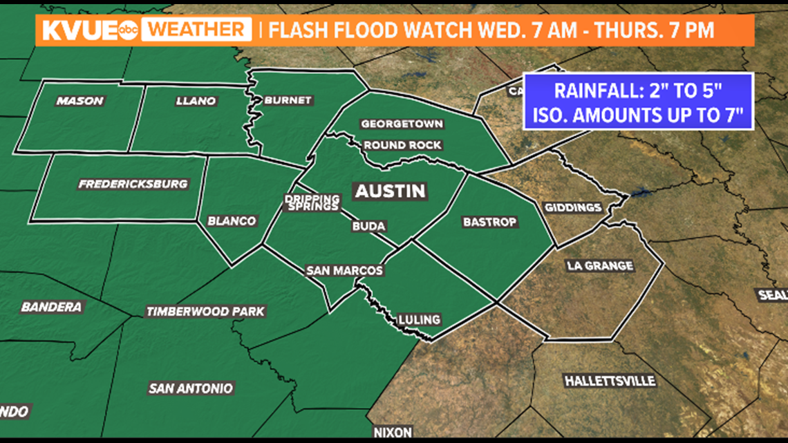
The most recent forecast model runs from Wednesday afternoon show larger rainfall totals spreading further east. This means rainfall projections for the I-35 corridor have increased to 2 to 5 inches. Isolated areas could receive higher totals. Therefore, we can't rule out half-a-foot of rain or more for some locations. Lower totals of 1 to 2 inches will be possible southeast of Austin.

Timeline of storms
Wednesday night: This is when the main round of showers and storms will be pushing through. Heavy rainfall rates will be expected at this time with strong showers and storms moving into the Hill Country late Wednesday night. Flash flooding will be likely with saturated grounds already in place. There is a low-end threat for severe weather overnight. Aside from heavy rain, there is a potential for gusty winds, hail and a low-end threat for an isolated tornado.

Overnight Wednesday and into Thursday: Storms will continue to push from west to east overnight and will impact the I-35 corridor. This means we need to remain weather aware, especially overnight with multiple ways of receiving weather alerts. There is a low-end threat for severe weather overnight. Aside from heavy rain, there is a potential for gusty winds, hail and a low-end threat for an isolated tornado. Rain clears out through the day on Thursday.

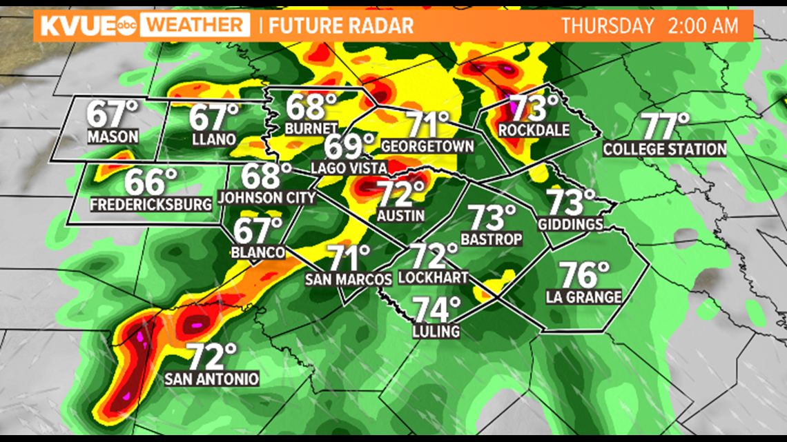
Thursday morning: Showers and storms will be clearing from the Hill Country and I-35 at this time, but our eastern counties will likely be dealing with the bulk of the activity by Thursday morning.


Another cold front arrives Friday with cooler weather
Another cold front moves through Friday and brings our first true taste of fall for next weekend! This means a huge cooldown with highs dropping to the 70s and morning lows in the 40s and 50s.

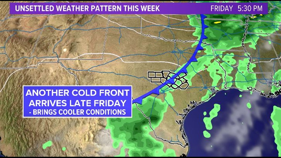
A strong northerly breeze also brings drier air to Central Texas. So, overall, we're expecting a sunny and cool weekend that finally feels like actual fall.
The KVUE Storm Team will continue to closely monitor this developing forecast.
In the meantime, the extended forecast can be found below: